
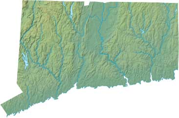
Connecticut Relief Map
Static Connecticut Relief Map
Interactive Connecticut Relief Maps
The interactive relief map choices include a standard Google terrain map and an enhanced Google terrain map with Street View capabilities. To zoom in or out on either of these Connecticut maps, click or touch its plus (+) button or its minus (-) button, respectively. To pan either map in any direction, simply swipe it or drag it in that direction. To display either of these Connecticut terrain maps, click or touch one of the following menu options.
Connecticut's highest mountain is Mount Frissell, whose peak is 2,380 feet above sea level. The largest lakes in Connecticut include man-made Candlewood Lake and natural Bantam Lake. If you are planning a visit to Connecticut, please see Visit Connecticut, the official state tourism site, where you can find a wide range of travel and vacation information. For information about Connecticut history and recreational activities, visit the following National Park sites.
Connecticut National Parks
- Appalachian National Scenic Trail
- Quinebaug & Shetucket Rivers Valley Corridor
- Weir Farm National Historic Site
Copyright © 2005-2025 State-Maps.org. All rights reserved.
Connecticut-Map.org is a State Maps reference source.
To facilitate browsing, certain external links will open in new windows.
Connecticut-Map.org is a State Maps reference source.
To facilitate browsing, certain external links will open in new windows.